Hiking Route 1
Route: CHORIO-SELADI-MAVRODASOS-ELLINIKA
Route marking number: 1, total route length: 7 km.
Starting off at Chorio, you follow the concrete road by the bridge, located behind the OTE building, then a dirt road of 2.800 m. length approximately, and then you reach the beginning of the trail after passing by a well-preserved outdoor “omproudektis” (a cistern used to collect rain water in the past) of other times and needs.
The first distinctive metal sign with the number 1 that you will find on a rock, will lead you to a well-preserved cobbled-road through olive groves and grape vines. The cobble-road descending continues to a path in the bed of a dried stream. Soon you leave the riverbed to turn right in another old cobble-road ascending through tall stone walls in an area called Mavrodasos. A bit later the olive groves become less dense and the view of the northern coast of Milos island is unfolded before you .The trail goes on a slope through multiple terraces while on the lower left one can see the continuation of the stream. After successive alterations of downhill and uphill points you will see from above Ellinika beach and you will descend to the beach from a dirt road that is connected to the trail. If you head towards “Deka” beach you can take the bus and return to Chorio.
Alternatively: You have the option to continue walking from Ellinika heading west to Mavrospilia, where at the end of the beach, you will find a dirt road and the trail number 2,which will lead you to Skiadi and then to “Sklavos” point. Then you can follow the path that will lead you back to the village, completing in that way a circular route.
Route marking number: 1,total route length: 7 km.
Hiking Route 2
Route: CHORIO-SKLAVOS-SKIADI-MAVROSPILIA
Total route length: 8 km.
The first section of the trail is a road that starts at Chorio, goes on turning left after the OTE building just before St. Eustatius chapel. Continuing on this road, you will arrive at the location “Sklavos”, where you will find the signs with the marking numbers of trails 2 and 3. You follow them up to the old, yet very well-preserved cobbled-road that passes through olive groves, vegetable gardens and picturesque stone walls.
A bit after passing by two old stone farmhouses on the left of the old cobbled-road (about 800 m. from the starting point at Sklavos) you will see on your right side a junction to the trail number 3. You will have to continue on the trail number 2 ignoring the following junction that leads to Makropounta and slightly descends heading to the south.
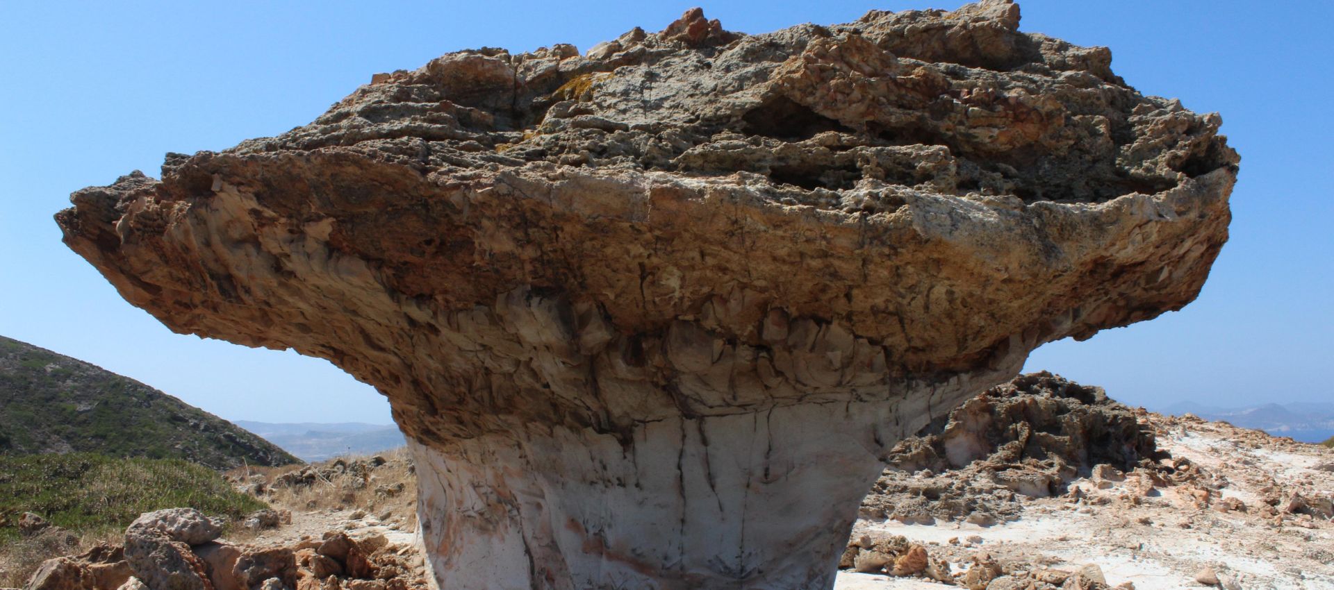
After reaching a farmhouse, the landscape changes and you are now hiking on a ground of uniquely formed geological rocks that lacks vegetation. These unique rock formations will rouse your imagination until, after reaching a small mound, you will see in front of you “Skiadi”, a monolith stone in the shape of a mushroom, a rare geological formation whose shade can offer you a place to rest, since it looks like a tree made of stone. After getting some rest, you follow the marking sing number 2 and you go down the slope while enjoying a wild scenery. You arrive at the bed of a stream, continue on the opposite side going up and then turn left until you find again the old cobbled-road which the farmers of the island used to take to get to the place where they kept their money. Now, at about the same level, overlooking the northern coasts of Milos from the south and deserted farmhouses from the west, you move following the signs, you pass by and old corral that you will see on your right side and then gradually the landscape is once again surrounded by olive gropes. Soon, further down the road appears first the small, yet very beautiful beach “Lakos”. In order to reach Lakos you will have to take a shortcut that passes through grassland. Following the path that goes downhill on the slope, you will arrive at the bed of a stream which has been turned into a dirt road. This dirt road leads to the westernmost point of “Mavrospilia” beach where you will see cottages scattered every now and then as well as big trees on the dirt road that is parallel to the beach.
Alternatively: There is the option of resuming from Mavrospilia towards Ellinika heading east, from where, at the end of the beach, there is a dirt road and the trail number 1 which you can take to get to Mavrodasos and then to a location called “Seladi”. From Seladi you can follow the dirt road which will lead you back to the village, completing in this way a circular route.
Route marking number: 2, total route length: 8 km.
Hiking Route 3
Route: CHORIO-SKLAVOS-PALIOKASTRO-KASTRO-THERMOPIGI
Total route length: 8,5 km.
The first section of the trail is a road that starts at Chorio, continues turning left after the OTE building, just before St. Eustatius chapel. Continuing on this road you will reach a location called “Sklavos” where you will find the signs with the marking numbers for trails 2 and 3. Follow them up to the old, yet very well-preserved cobbled-road that passes through olive groves, vegetable gardens and picturesque stone walls.
A bit further down the road, after passing by two stone farmhouses on the left side of the old cobbler-road (about 800 m. from Sklavos), you will see on your right side a junction to trail number 3 which you will follow and head northwest. 450 m. further you will once again reach a junction and a typical old farmhouse. There you will follow the path on the right with the marking sign number 3 heading north, and you will walk between old stone buildings, which make the route appear very quaint, in the area called “Kefales” . This path offers the most amazing view of the Aegean and of almost all the sides of the island and of all of Kimolos’s paths, and passes very close by the highest peak that is called “Paleokastro”, where there are ruins of the ancient castle. As soon as you come across a natural pond, you will start descending, following the right marked path at the last junction overlooking the beach “Monastiria”. From the beginning of the trail you will be walking through olive groves, terraces and stone walls. Progressively, you will start descending while gazing at the Aegean on your left and admiring impressive rock formations on your right , that, with a little imagination, can be associated to many different interpretations. Continuing downhill, you reach a well-preserved threshing floor, and a bit further you can see a small house carved into a smooth rock. From that point, you have to carefully follow a steep downhill section of the right side of the trail on the east side of the rock behind it. You pass through an abandoned vineyard and, continuing on the trail with the same marking sign, among olive grove terraces you arrive very close to a small stream from where you can access “Kastro” beach. There you will see many trees and 40 m. from the beach’s left side there is a well known hot spring, a small, horse-shoe shaped beach where there is constantly running hot spring water. If you do not descend towards the coast and decide to continue uphill and to the north, you will be led to the second beach of the area, called “Agioklima” in 15 minutes’ time, where you can rest at the shade of the 2 big trees of the beach.
Alternatively: You can complete a circular route by continuing on trail 5 from Agioklima, following the helpful marking and going uphill and northeast through the terraces and the olive groves. After passing by deserted farmhouses on your left and right side, you will find the old cobbled-road and you will reach a mountain pass at the location “Gampas” where there are impressive, smooth rocks. Continuing on the path, which is literally carved into the rock, heading southeast at first and then south, you reach the chapel of Panagia Cheimeli and then, passing through another cobbled-road you descend to the dirt road that will lead you to Chorio from another way.
Route marking number: 3, Total route length: 8,5 km.
Hiking Route 4
Route: CHORIO-KSEVRI-MATSA-GADAROMANTRA-MONASTIRIA-ORMOS SOUFI
Total route length: 6,5 km.
The first section of the path is a road that starts at Chorio and goes on turning left after the OTE building, just before St. Eustatius chapel. You follow a very well-kept cobble-road that passes through terraces of cultivated olive groves and stone walls made by the typical colorful rocks of Kimolos.
On your lower right side you will find another cobbled-road where you’ll see the unique old stone bridge of the island, as well as the eastern trail and road network of the island. Moving on to Ksevri area, you can see all around the scattered chapels of Kimolos’ countryside and the geological terrain of the –almost round- island. Going up the road without having to climb any steep slopes, a bit further from the St. Catherine’s chapel, you will reach a dirt road that will lead you to a junction of dirt roads. There you will have to follow the path that is a bit further down the road, on your left side and has the marking sign number 4. At first the trail descends the mountainside, then it passes through a location called “Gadaromantra”, alongside the creek that in some spots forms ponds of water that are maintained even throughout the summer period. When reaching a junction, you will always need to keep following the marking signs with the number 4. You will pass by a building that you will see on the left, and then for some meters you will notice that the path is not easily distinguished. However, a bit later the trail moves on in the bed of a stream and it is in a very good condition, wide and fordable , while surrounded by the mountain slopes both on the left and the right side. This great trail will lead you through vineyards and dense reeds to Monastiria beach which is located north and where you can enjoy the ocean waves and the wonderful sand. You will have to keep walking until you reach the rocks on the left side of the coast and then, following the marking sign 4 that’s on the rocks, you will arrive at Soufi Bay, that very efficiently offers shelter from the wind, in 15 minutes’ time, after walking for a bit on a path section above the sea. On this sandy shore there are trees offering shade and 2 boat-houses. If you climb on the rocks at the end of the coast ( you can see them from the path), you will be impressed by the spectacular, colorful, some smooth and some rough rocks.
Route marking number: 4 Total route length: 6,5 km.
Hiking Route 5
Route: CHORIO-CHIMELI-GAMPAS-AGIOKLIMA
Total route length: 6,8 km.
The first section of the path is a road that starts at Chorio, goes on turning left after the OTE building, just before St. Eustatius chapel. You follow a very well-kept cobble-road that passes through terraces of cultivated olive groves and stone walls made by the typical colorful rocks of Kimolos.
On your lower right side you can see another cobbled-road with the unique old stone bridge of the island, as well as the eastern trail and road network of the island. Moving on to Ksevri area, you can see all around the scattered chapels of Kimolos’ countryside and the geological terrain of the –almost round- island. Going up the road without climbing any steep slopes, a bit further from the St. Catherine’s chapel, you will reach a dirt road that will lead you to a junction of dirt roads. There you can select either to follow the downhill cobble-road leading to the dirt road where there is a cemented underground water tank with a trough, or you can follow the downhill dirt road until you reach the tank. In this point there is an uphill, well-preserved cobble-road with the marking sign number 5. Going up, it passes beneath the chapel of Panagia Chimeli and then leads to a col overlooking the north coasts (Monastiria, Vromolimni etc.) and Chorio. After the col, the well-kept cobble-road continues for about 20 minutes at the same level and leads to a smooth, wide rock where you can enjoy a panoramic view of the whole north side of the island. Following the marking sign number 5 on a path almost carved into a rock at “Gampas” location, you keep walking on the cal where, passing by some farmhouse ruins on your right side, you begin to descend turning left and downhill heading west. As the well-maintained path goes down, it passes by deserted cottages and through olive groves and dense vegetation, and finally leads to Agioklima, a beach that has two big trees offering shade, wonderful sand and crystal clear water. You can also reach Thermopigi by swimming; a place where hot water flows from a spring inside the sea.
Alternatively: You can complete a circular route by ascending for 100 meters approximately from the beach and follow the path on the right heading south, which crosses “Kastro” beach. Soon you will find the marking sign number 3 and if you follow it, it will lead you, following a different route, to Kefales and Sklavos from where you can return to Chorio by taking a dirt road.
Route marking number: 5 Total route length: 6,8 km.
Hiking Route 6
Route: CHORIO-SKLAVOS-PATELIDA-MAKROPOUNTAS
Total route length: 8,3 km..
The first section of the trail is a road that starts at Chorio, goes on turning left after the OTE building just before St. Eustatius chapel. Continuing on this road, you will arrive at the location “Sklavos”, where you will find the signs with the marking numbers of trails 2 and 3. You follow them up to the old yet very well-preserved cobbled-road that passes through olive groves, vegetable gardens and picturesque stone walls.
Soon after passing by two old stone farmhouses from the left side of the old cobble-road (approx. 800 m. from the beginning of the route at Sklavos), you will see on your right side a junction with the path number 3. You should continue on the path number 2. At the next junction you come across, you will see a sign that says “Patelida” and “Makropounta” and you will turn right to follow this path. From the point where the junction with the path number 2 is, the trail traverses smoothly until it reaches the trail junction that we see in our map. From this point, the trail goes up a rough, rocky and almost inaccessible due to thorny short plants path, until it reaches the building/house and the viewpoint. The path/cobble-road is paved with stones for the most part and is not marked. Moving on, you arrive at a plateau, a “patelida” (limpet) as it is called in the local dialect, with threshing floors and scattered abandoned, old farmhouses, a sign of frequent agricultural activity in the recent past of the island’s life. If you do not follow the uphill trail and continue walking towards Makropounta, traverse until you reach the floor 2 that overlooks the sea, offering a great view. Then you head north for a little bit, descending smoothly on a path-ridge; then,as soon as you pass by a ruin, you head southwest at first and then west on a not very easily distinguished trail until you are led to Makropounta beach, which is constantly visible during our well-designed route.
Route marking number: 6 Total route length: 8,3 km.
Hiking Route 7
Route: CHORIO-KORAKIES-ROUPAS-MONASTIRIA-ORMOS SOUFI
Total route length: 4,7 km.
The first section of the trail starts off at Chorio, passes by the OTE building, turns right and downhill a little after St. Eustatius chapel. Follow the very well-preserved cobble-road that passes through terraces of cultivated olive groves and beautiful stone walls, and has no marking signs.
Soon, on your right side you will see a stone bridge of great architecture; you continue your way on the cobble-road which shortly meets a dirt road and some junctions. On the first junction you turn left, and, while the dirt road continues, you leave it when you arrive at Korakies, where you will go up a section of the path that was “saved” from being paved as well. Ascend this path until you come across 2-3 wrecked stone buildings and then again a dirt road at the location called “Roupa”. From this point, take the wide dirt road on the right, with the sharp turn and the intense water channels phenomenon overlooking at Monastiria beach. At the end of the road there is the Panagia Monastiriotissa church where you can rest or visit at any time since it is always open. This chapel is a remnant of a larger complex of monasteries that were destroyed with the passage of time. When you arrive at the great north and sandy beach Monastiria, you can swim or continue hiking until the other side of the beach where, on the edge of a cliff you will find the marking sign with the number 4 for the path that leads to Soufi bay. If you follow it, you will climb up the path that is visible on the rock, and after 15 minutes you will be arriving at the amazing and well protected by the winds, Soufi bay. On the beach there are many trees for shade and 2 boathouses.
Route marking number: 6, Total route length: 4,7 km.